

Road trip to the Great States of Kentucky and Tennessee
Just Get Off The Couch and Light It Up
in the Smoky Mountains!
The Salty Travelers decided to hit the road in a rented minivan because COVID cancelled any and all travel plans that we had made for the year. We were anxious to get out of the house and see the world, so why not head to the nearest mountain range and get salty? I had wanted to check out the Appalachians, so no better time than the present.
With our two Bernese Mountain Dogs in tow, we loaded up the van and headed South. We decided to stop at three different parks to minimize the drive time spent in the car with the dogs.

Kentucky sunset
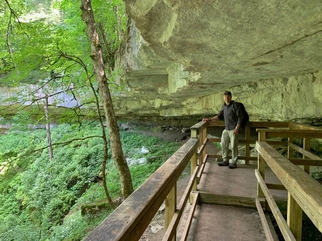
First stop: Mammoth Caves National Park
Our first stop was the Mammoth Caves National Park near Bowling Green, Kentucky. Mammoth Caves boasts the world’s longest cave system (400+ miles) below ground. The surface has 70 miles of trails to hike, 13 backcountry campsites, and 20 miles of river to explore. Two Worlds in one!
Tip: Do NOT rely on your GPS to get you here. It often takes the long way around (I hate when that happens) and you may be late for a tour. Instead, follow these directions from the National Park Website.
Due to Covid, my Pepper and I were limited to only doing the self-guided Extended Historic Tour. The website claims that this $18 tour takes approximately 90 minutes with a moderate level of difficulty. Perhaps my perspective comes from a place of hiking experience….but this was NOT a moderate level tour. Their were kids, the elderly and random tourists all over the place. It took us about 20-30 minutes at the most. It is essentially “a walk in the park,” in the dark! I was disappointed, but it was pretty cool to see such an expansive cave system from the inside.

The famous entrance to the Extended Historic Tour
If you are an adventure seeker like I am, then the Wild Cave Tour is a MUST! Travel through 5 miles of undeveloped passageways by free-climbing, crawling, squeezing through tight openings and slipping through wet areas as you make your way through the cave. This is an Adults Only Tour- and good physical condition is essential. If my Pepper and I go back, this is the tour we will do! Otherwise, check out this list of available tours for you and your family. The best all around tour for families is with small children is the Frozen Niagara Tour. This section of the cave will take less than an hour to see, with minimal stairs and larger caverns to ease the fears of claustrophobia.
If hiking is your thing, there are six trailheads here that are cut in half by the Green River. This divides the park into the Front country and Back country trails. We had limited time so we hiked the easy 3 mile Turnhole Bend Trail.. This is labeled an “intermediate” hike, but again, it was an easy loop with a gradual uphill trail. The far more interesting short hike was the Cedar Sink Trail just down the road. As you hike along the rim of the sink hole, you gradually descend down into this astounding geological feature. The view gets better as you hike out of it and realize how deep it really goes- as you gasp for breath on the uphill climb.
Heading into the sinkhole
If you have more time, check out the Backcountry Trails, which are bustling with equestrian traffic and local hikers out enjoying nature. Combine a few trails to make one long hike, or head to the most popular long distance trail, which begins at the Temple Hill parking lot. The McCoy hollow Trail is a 6 mile one-way trail which winds around steep ridges, streams and rock walls. Back track to make it a long 12 mile hike or camp and tackle the way back in the morning! Watch out for drop offs and slick rock that gets wet from the river.
Lastly, if you would rather let someone else do the work, take a tour of the Green River via motorboat, kayak, or canoe. For all of you anglers out there, fishing is allowed without a license in the park. Head to The Big Woods, Sloan’s Crossing Pond, and Cedar Sink.
Second stop: The Great Smokey Mountains National Park/Gatlinburg, TN
Gatlinburg, Tennessee is nestled in the valley of the Little Pigeon River and surrounded on three sides by the Great Smoky Mountains National Park. It lies on the southern end of the Appalachian Mountains, with 522,427 acres of outdoor fun. There are 800 miles of hiking trails, including 70 miles of the famous Appalachian Trail. While the town itself made me a bit salty with all the t-shirt shops, tattoo parlors, tacky stores and hoards of people, the hiking was majestic and serene- just what we needed during such a strange time in our country.

View of the Smoky Mountains from our cabin (can you guess where the name came from?)
Here are a few recommendations for some of the best hikes within the park:
Newfound Gap/Charlie Bunion Trail:
The hike to Charlie Bunion begins at the Newfound Gap Trailhead. This is an 8 mile roundtrip moderate-difficult trail with an elevation gain of 1640 feet. The highest elevation you will reach is an 6122 ft. Arrive early to find a parking spot before the crowds get here! We started our hike about 8am and the lot was about half full. The trailhead is to the right of the public restrooms, and part of the Appalachian Trail!

Here we go! It was pretty cool to hike a part of this historic trail…
The first two miles are a steady climb, which tends to dissuade the casual photo-seeker from traveling any further. It was nice to get away from the crowds and just take in the cool, moist air. Along the trail you are rewarded with beautiful views of the North Carolina Smokys and non-stop greenery. It is wet, lush and green due to constant moisture from rain and fog. You are surrounded by this beauty the whole way!

Such beauty in Mother Nature
Once you reach the ridge, you will be hiking at around 6000 ft. There is a shelter where you can get a refill on water (don’t forget to bring a water purifier!) that runs nearby the aptly named Icewater Spring Shelter. Continue to follow the signs (the trail is well-marked) to the Charlie Bunion trailhead- and relish in the sight of of those brave souls making the through-hike all the way to Maine. Its a cool sight to see!

The Charlie Bunion Rock is the background as I make my way along the steep cliffside walkway- don’t look down! Its a little scary…
At about 4 miles from the trailhead a short trail branches off to the left and leads to Chalie’s Bunion, a giant, bulbous rock formation with great views. Its a perfect spot to stop for a snack or lunch. Watch your step, as there are extremely steep drop-offs. You will see spectacular views (if its not foggy) of Mount Guyot to the east and Mount Kephart to the North.

There he is…and now its time for a snack and a rest before my Pepper and I head back.
Chimney Tops Trail:
The Chimney Tops trailhead parking lot is small, so head over early. Otherwise, you may have to find a spot along the road. We arrived by 7:30am and scored one of the last spots available. This hike is a 3.6 mile out and back hike that is rated as difficult. The “difficult” part is the quick 1289’ elevation gain! Just be sure to take a lot of breaks and bring plenty of water. There are four bridges to cross- so it is a good excuse to stop, catch your breath, and take some pictures! Other than the elevation, the trail is groomed and easily walkable.
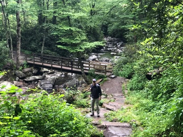
The river crossings were beautiful!
And did I mention the fun, small waterfalls? Stop, take a break, and enjoy the sweet sounds of nature along this steep trek.

How cool is this?!
The last part of the trail is closed due to fire damage- but many people were skirting past the barrier fence and hiking out to the rim. Just make sure you have sturdy shoes with a good grip as the rock can get slick.

The “Chimney” had smoke coming out of it!
Rainbow Falls:
My favorite hike of the trip was Rainbow Falls. It begins at, ironically, the Rainbow Falls Trailhead! It is 5.4 miles roundtrip with an elevation gain of 1685 ft. This hike is rated as moderate- which I tend to agree with. However, due to the length, the elevation gain, the steps, and the rocky terrain, some may bill this as difficult. We passed so many hikers who were begging for the end! The quick elevation gain makes it seems longer than it really is. Allow 3-5 hours depending on your fitness level. We made it out and back in about 3:40:00 with a snack break at the waterfall. Rainbow Falls is really beautiful, surrounded by rock and trees. Be careful if you decide to climb behind the Falls, the rocks are slippery!
Tip: Black bears are often seen on this trail. Please read what to do if you see a bear.

It was so beautiful here! Grab a snack and take it all in…
If you are feeling particularly energetic, (we were not, this was our second hike that day), continue hiking past the waterfall for 4.2 more miles and head to the summit of Mount Le Conte, the 3rd highest peak in the Smokies.
Roaring Forks Motor Trail:
If you are tired from hiking or just want to take it easy, the Roaring Fork Motor Trail is a good bet. It is a drivable, one-way scenic 6 mile loop that takes you past mountains, streams, mills and other historic buildings. There are turnouts along the way to park, so bring a picnic lunch, go for a brief hike, and have some lunch. The Trillium Gap Trail is an easy hike to a waterfall, and so is the Place of a Thousand Drips at Turnout 15. Either way, have drinks and a snack because there is no urning back once you start driving this trail.
To find the entrance, turn on Traffic Light #8in Gatlinburg onto Historic Nature Trail Road. Follow the road to the entrance to the park. Th Roaring Forks entrance is just past the rainbow Falls Trailhead.
Gatlinburg Trail Hike:
On our way out of town we decided to take our big furry kids on a short hike along the river. Honestly, I wish we would have done this hike very day with them! The Gatlinburg Trail is a 3.8 mile round-trip trail runs along the Little Pigeon River. It was so peaceful despite loads of walkers and runners around us. This is one of the few places where dogs are allowed on the trails, so enjoy! But don’t forget to pick up after your pooch, too.
It begins near the Sugarlands Visitor Center- just pull into a parking spot and off your go!
Tip: For a quick sidetrip- look for the Cataract Falls trailhead and take a quick walk to an impressive tiered waterfall!

The boys were loving the wooded trail- and Dreyfuss got a drink from the river!
Another fun idea while in Gatlinburg:
The town of Gatlinburg is not my scene. However, you may want to check out the chondola at Anakeesta- for a $22 bucks hop on a gondola that takes you from downtown Gatlinburg to the summit of Anakeesta. At the top there is a bunch of stuff to do- ziplines for the kids, cocktails for the adults…or just hang out and take in the views of The Great Smoky Mountains.
Third stop: Red River Gorge, Kentucky
Our last couple of days were spent in East-Central Kentucky in the Red River Gorge Geological Area. The gorge lies within the Daniel Boone National Forest, and has been designated a National Natural landmark. The intricate canyon system of sandstone cliffs, water falls, and natural bridges have made this area one of the worlds top rock climbing destinations. we, however, decided to hike and kayak here instead.

The trail markers here were white diamonds instead of the usual white slash mark-like on my t-shirt!
There are over 100 natural sandstone arches to hike to, and Natural Bridge State Park is adjacent to the area. More details about that later.
With so many options to choose from, we had a tough time narrowing down where we wanted to go….so we decided on Courthouse Rock Trail for a beautiful view, a little challenge, and an afternoon out in the wilderness.

The trail to Courthouse Rock was a moderate trail, but soooo humid!
Courthouse Rock Trail: Travel to the Auxier Ridge parking area. Hike either the Double Arch Trail or the Courthouse Rock Trail to the junction for Auxier Ridge. This moderately difficult trail system can be up to 8 miles round trip depending on which of the 4 trails you choose to hike. There are stairs that you take to get to the Courthouse Rock- and there is also a stream crossing that gets pretty hot and humid in the summer. You will be at the base of the gorge walking along the stream- enjoy the view and the free steam bath!

The Courthouse Rock hike is in the palm of my hand!
Indian Staircase:
A second worthwhile hike is the iconic “Indian Staircase’- in quotes because it is not an official trail, for some reason. This hike is not for the faint of heart- it is, literally, pockets sculpted into a bulbous sandstone cliff. Watch your step! The hike is about 3.5 miles on an unmarked trail so take note of your surroundings or use a compass. It requires some rock scrambling and some serious balancing moves to make it to the top.
The imaginary trailhead begins at the Bison Way Trail Parking Area on KY 715N. Follow the Bison Way Trail to Sheltown Trace #100 and start counting the number of times you cross a stream- this may be the best way for you to find your way back! After the second stream, make a hairpin turn and look for an unmarked trail to the right. This is the start of the Indian Trail Staircase.
The Gorge Underground Kayak Tour:
I had to mention this activity because it so cool! The Gorge Underground is an abandoned limestone mine that is now used for kayaking and paddle boarding. It is an hour long adventure in the darkness! No special skills are required- there is a slight current, so you barely have to paddle to keep up with the guide.

The water is so clear you can watch the giant trout swimming in the water
If you have time to head to Natural Bridge State Park,, adjacent to Red River Gorge, and spend a day or two hiking and paddle boarding. This is a far more touristy area than Red River Gorge- but it may be interesting to check out. The bridge itself, made of natural sandstone, took millions of years to form. It spans 78 feet and is 65 feet high! The hike to the arch is 0.75 miles. Take the 11 minute (ski lift) Sky Lift if you would rather NOT hike up to see the Bridge. The Skylift is a half mile from the park entrance and ends within 600 ft. of the Natural Bridge. You will be able to walk on top of this sidewalk in the sky!
There are also 10 hiking trails here- with the Auxier Ridge Trail #204. This is an intermediated level trail and takes about 4 hours to finish.
You can also rent a kayak or a paddle board through Red River Adventure for Mill Creek Lake on weekends and holidays..